01_Project Specs
Jerusalem
2026
Technical
First-place graduate thesis prize; manuscript in preparation
Restoring the Jewish Temple: A Spatial Study
BIM/GIS Integration & Historical Reconstruction
Historical reconstruction required aligning uncertain archaeological evidence with architectural precision.
Combined BIM modeling, GIS control data, Monte Carlo testing, and iterative drawing studies.
A documented spatial model, analytical diagrams, and a navigable image archive.
Revit, PyRevit, QGIS, PyQGIS, Python, TwinMotion

Overall spatial reconstruction of the Temple Precinct.
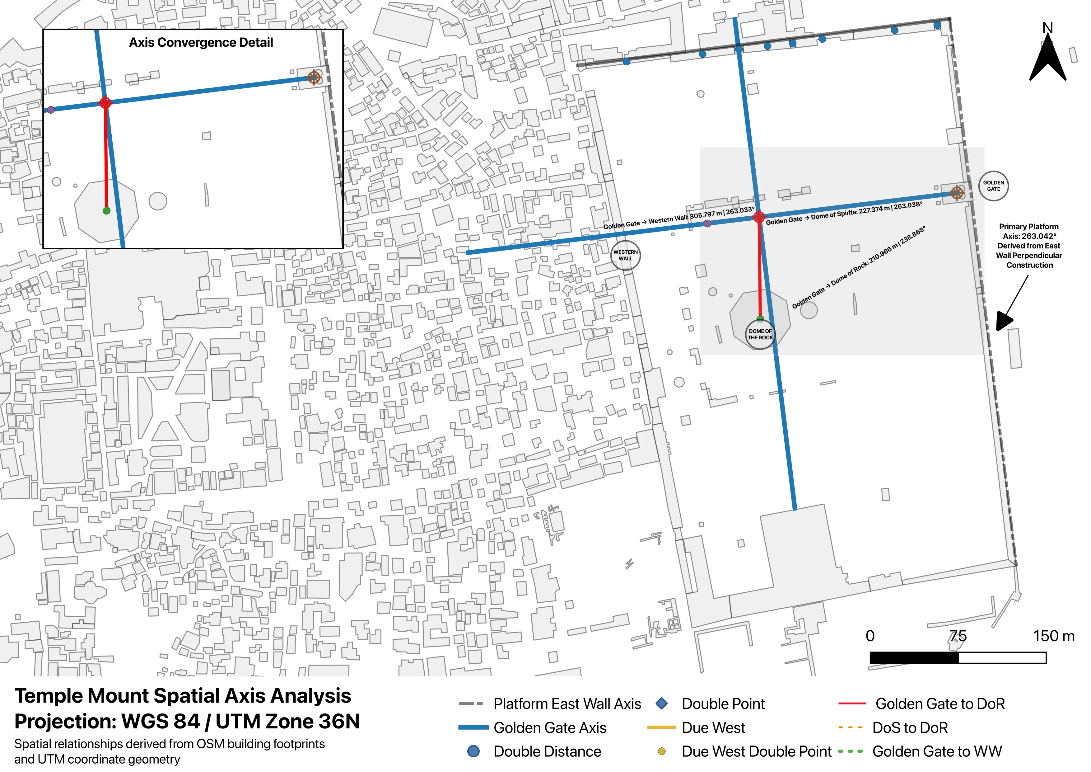
A spatial study that treats one of the most contested reconstruction questions in architecture as a testable geospatial problem. Rather than beginning from inherited placement traditions, the project translated textual, archaeological, and architectural evidence into measurable constraints and asked a narrow question: do the spatial relationships on the existing platform converge in a statistically meaningful way when tested against uncertainty? The output is a bounded candidate zone — not a location proof. The analysis supports the plausibility that the Foundation Stone belongs to a wall of the Herodian temple courtyard rather than the sanctuary itself, placing the reconstructed Temple on the east–west axis of the Golden Gate, approximately 80–100 meters east of the Dome of the Rock. The resulting proposal preserves all existing structures on the platform and frames the precinct as shared sacred space.
All geometry was consolidated into EPSG:32636 (WGS 84 / UTM Zone 36N) within QGIS and PyQGIS. A five-stage workflow moved through data preparation, observed-model construction, Monte Carlo uncertainty modeling, null-orientation comparison, and leave-one-out sensitivity testing. Dual-environment validation — primary construction in QGIS, independent blind retest in a Python repository — reduced the risk of results being artifacts of the GIS session. The observed constraints converged more tightly than randomized orientation models, defining the candidate zone against uncertainty. The architectural translation follows a Haggai-era register — a modest restoration under constrained circumstances rather than a maximal Herodian reconstruction — expressed through parametric cubit-based overlays, footprint and altar-offset studies, and processional axis diagrams anchored to the eastern gate alignment.
Software
Revit, PyRevit, QGIS, PyQGIS, Python, TwinMotion
Focus
Historical Restoration, BIM/GIS Integration
Scale
Site-wide analysis
"The precinct organization is derived from a strict axial system that aligns the archaeological remains with topological signatures."
ISO_01 // TECTONIC_REASONING
This project is part of a broader investigation into computational heritage documentation. Refer to the Research Archive for technical methodology.
View Research